Karur district is one of the 38 districts of Tamil Nadu state in India. It’s locally called ‘Karur Mavattam’ in Tamil Language and it covers an area of 3,022 Square Kilometres. Tamil is the native language for people living here. As per the 2011 census, the population in Karur is 10,64,493.
Karur district consists of 7 Taluks, and Karur taluk is the district headquarters. This district is located exactly at the center of Tamil Nadu state. It consists of both rural and urban areas; of which the major portion is semi-urban. ” MyKarur is the Brand Name for Karur “, which provides complete details about the Karur district.
Formation of Karur district
Karur was initially a part of the Coimbatore district which is called Kongu Nadu. In 1910, it became a part of the Tiruchirappalli district.
On 30th September 1995 Saturday, Karur district was formed by separating it from Tiruchirappalli district in Tamil Nadu. In 2001, the district consisted of 4 taluks; Karur, Aravakurichi, Kulithalai, and Krishnarayapuram.
Kulithalai taluk was divided into two taluks namely Kulithalai and Kadavur taluks. In 2011, there were 5 taluks in the district. As of 2021, there are 7 Taluks in this district. Trichy to Karur distance is 82 KM via Kulithalai
Karur District profile
The Karur District is divided into two revenue divisions namely Karur and Kulithalai. which is further split into 7 Taluks containing 203 Revenue villages.
There are 7 taluks in the Karur district and the list of taluks are mentioned below
- Karur taluk
- Aravakurichi taluk
- Kadavur Taluk
- Kulithalai Taluk
- Krishnarayapuram Taluk
- Pugalur
- Manmangalam
There are 8 blocks in Karur district, they are
- Karur,
- Thanthoni,
- Aravakurichi,
- K.Paramathi,
- Kulithalai,
- Krishnarayapuram,
- Kadavur,
- Thogamalai
The district is governed by two Municipalities namely, Karur & Kulithalai.
The district consists of 11 Town Panchayats. They are
- Aravakurichi,
- Krishnarayapuram,
- Marudur,
- Nangavaram,
- Palaya Jeyamkonda Cholapuram,
- Pallappatty,
- Puliyur,
- Punjai Thottakurichi,
- Punjai Pugalur,
- TNPL Pugalur,
- Uppidamangalam.
There are 8 Panchayat Unions in the Karur district. They are
- Karur
- Thanthoni
- Aravakurichi
- K.Paramathi
- Kulithalai
- Thogamalai
- Krishnarayapuram
- Kadavur
Karur district Population
Male :- 5,28,184
Female :- 5,36,309
Total :- 10,64,493
Education institutions
- Primary Schools:- 575
- Middle Schools:- 188
- Pre-primary Schools:- 79
- High Schools:- 62
- Hr. Sec. Schools:- 80
- Matriculation & Matric.Hr.Sec. School:- 59
- Government I.T.I:- 1
- Self–Financing College of Engineering:- 7
- Govt.College of Arts & Science (Male/Female) :- 2
- Self-Financing College of Arts & Science:- 8
- Govt. Music School:- 1
- District Institute of Education & Training:- 2
- Govt. Polytechnic College:- 1
Literates
- Male :- 401726 55%
- Female :- 325318 45%
- Total :- 727044 68%
Categories of workers
- Cultivators:- 83800
- Agricultural Laborers:- 182639
- House Hold Industry:- 10162
- Other Workers:- 231906
Total Workers:- 508507
Karur district land classification (IN HECT)
- Forests: 6187.115 2.14%
- Barren & Uncultivable land : 2785.460 1%
- Land put to Non-Agricultural use: 37631.270 13.0%
- Culturable Waste: 65130.72 22.49%
- Permanent Pastures & other Grazing Land: 10800.980 3.73%
- Land under Miscellaneous Tree Crops & : 2336.645 0.81%
- Current Fallow Lands: 45541.23 15.73%
- Other Fallow Lands: 72302.29 24.97%
- Net Area Sown: 46840.925 16.18%
- Total Geographical Area: 289556.635.
Agriculture cultivated area (Hect)
- Paddy:- 13276
- Cholam :- 17556
- Campus :- 828
- Red gram:- 3605
- Chilies:- 442
- Sugarcane:- 2723
- Banana:- 3222
- Groundnut :- 4385
- Gingelly:- 3948
- Maize:- 2390
Total Cultivated Area:- 47462.47
- Food Crops Cultivated Area:- 18985.055
- Nonfood Crops Cultivated Area:- 11609.235
- Net Cultivated Area: 46840.925 98.69%
- Cultivated More than once: 621.545 1.31%
- Gross Cultivated Area (1+2) : 47462.47
- Net irrigate Area: 30022.42 98.13%
- More than once Irrigated Area: 571.57 1.87%
- Gross irrigated Area: 30594.29 64.46%
- Gross un-irrigated Area : 16868.18 35.54 %.
Animal husbandry departments
- Veterinary Hospitals:- 2
- Veterinary Dispensaries:- 58
- Clinician Centre’s:- 1
- Sub Centre’s:- 18.
Taluk wise population in Karur district
- Karur :- 445389
- Aravakurichi :- 183321
- Kulithalai :- 206731
- Krishnarayapuram :- 119213
- Kadavur :- 109893
Karur Weather and Temperature:
Karur Weather is 25°C at Night and 35°C during the daytime. It experiences a tropical climate with a warm temperature. The district receives Monsoon rainfall during October and November months. Summer will be hot with 40°C average temperature.
Karur district Rainfall (mm) details given below
South West Monsoon (June to September):- 213.6
North-East Monsoon (October to December):- 314.7
Winter Period (January to February):- 17.5
Hot Weather Period (March to May):- 109.2
District Normal Rainfall (MM):- 655
District Average Rainfall (MM):- 349.1
Urban areas
Karur district has both rural and urban areas. The urban area is called Karur city that covers a 2-kilometer radius around Karur central bus stand. This is where most of the home textiles units are present.
Karur taluk can be called the city part of the Karur district. This is where most of the hospitals in Karur, theatres, home textile units, government offices, colleges, and schools are present.
The district court, SP office, Karur collectorate, and RTO offices are located in the Thanthonimalai area, within the Karur city limit. The cost of a New House for sale in Karur urban area is high.
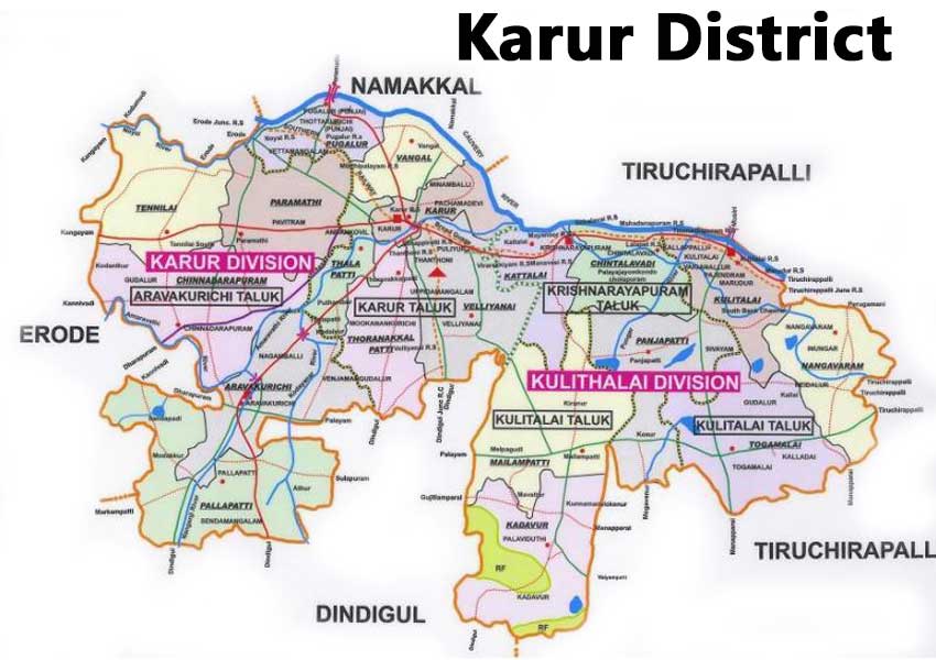
Karur district map
Karur district map shows the district is bounded by:
Tiruchirappalli district on the east.
Namakkal district on the north.
Dindigul district on the south.
Tiruppur district on the west.
villages list
Karur district villages list consist of 203 Revenue Villages, which are further classified based on 7 taluks in Karur district. Aravakurichi taluk consists of 58 villages and is considered the biggest taluk of Karur. Kadavur taluk has only 22 villages and is the smallest taluk of Karur in Tamil Nadu.
Pin code
Karur District PIN code is 639001. This is the pin code for Karur Head Post Office in the Tamil Nadu state of India. The Department of Post, which is part of the Ministry of Communications in the Union Government of India, assigned the Karur pin code. The Karur Pin code was founded to make manual mail sorting and delivery more efficiently – thereby removing confusion caused by inaccurate addresses, similar town names, and diverse languages spoken by the general public.
Conclusion
Karur district is one of the oldest places in Tamil Nadu. It has tourist and worship places. Many industries here give jobs to Karur people. Karur Vysya Bank was started in the Karur district. It has Municipalities, Panchayats, and libraries. Most of the rural populations in Karur are into agriculture-aided jobs. Hope this blog article by Mykarur was helpful. You can submit feedback on the contact us page. The news about this district is published in Tamil Newspapers.
Frequently Asked Questions
Who is the Karur district collector?
Dr.T.Prabhushankar, IAS., is the Karur district collector From June 2021.
How many villages are there in the Karur district villages list?
203 Villages are there in the Karur district villages list
How many Taluks are there in the Karur district?
There are 7 Taluks in Karur district. They are
- Karur taluk
- Aravakurichi taluk
- Kadavur Taluk
- Kulithalai Taluk
- Krishnarayapuram Taluk
- Pugalur
- Manmangalam
What is the Karur district Pin code?
Karur district PIN code is 639001
In which state is Karur district?
Karur district is in the Tamil Nadu state of India. It’s one of the 38 districts in Tamil Nadu.
Are there tourist places in Karur?
Yes. There are many tourist places in Karur. You can check the following link for complete tourist places in Karur
Are there Industries in Karur?
Yes. There are many industries in Karur.
What are the types of industries in Karur?
Below are the types of industries in Karur
Bus Body Building companies
Mosquito Net manufacturing industries
Power Looms and handlooms
Spinning Mills
Textile Export units
Cement Pipes manufacturing
Bricks production
What are the major industries in Karur?
Tamil Nadu Newsprint & Paper Limited
Chettinad Cement
E.I.D.Parry Sugar Manufacturing Industry
What are the Major Banks in Karur?
Karur Vysya Bank and Lakshmi Vilas bank are the two major banks in the Karur district.
What are the municipalities in Karur?
There are two municipalities in Karur. They are
1. Karur municipality
2. Kulithalai municipality
How many Town Panchayats are in the Karur district?
There are 12 town panchayats in the Karur district.
What are the Town Panchayats in Karur district?
1. Punjaipugalur
2. Punjai thottakurichi
3. Kagithapuram
4. Puliyur
5. Uppidamangalam
6. Pallapatti
7. Aravakurichi
8. Maruthur
9. Nangavaram
10. Palaiyajayakondam
11. Cholapuram
12. Krishnarayapuram
How many schools are there in Karur?
List of Schools in Karur
1. Primary Schools:- 575
2. Middle Schools:- 188
3. Pre-primary Schools:- 79
4. High Schools:- 62
5. Hr. Sec. Schools:- 80
6. Matriculation & Matric. Hr. Sec. School:- 59
What is the population of Karur district?
Male :- 5,28,184
Female :- 5,36,309
Total :- 10,64,493
How many libraries are in the Karur district?
The list of libraries in Karur district is
1. Central Library:- 1
2. Branch Library:- 34
3. Village Library:- 54
4. Part-time Library:- 10
Are there any theatres in the Karur district?
Yes there are 10 theatres in the Karur district
Which is the largest multi-specialty hospital in the Karur district?
Apollo hospital in Karur is the largest multi-specialty hospital in this district
Comments are closed.